
 The mission on October 29, 2016, was to set eyes on the ancient sweet water springs that offered respite to native Wichita and Caddo for centuries and later served as the final watering hole for travelers on the Fort Cobb Trail before they set off to Soldier Creek near where Alex would later be located. During the Civil War, these same springs were a meeting place for Confederate troops. The springs were known 150 years ago as Elm Springs. Today, they are in the river-bound town limits of the village of Erin Springs.
My partner in crime today was a long-time friend, Cindy Foster Russell, who proved nimble as a billy goat and very well-versed in local flora and fauna. I could not have chosen a better accomplice.
We started out this adventure in a low-tech/high-tech way. Guided by coordinates taken from geo-referencing the 1871 Chickasaw Nation survey, we physically trekked over the banks of the Washita to prove where the Elm Springs were…or were not.
With permission from the landowner, we entered a (thankfully) recently mowed meadow flanking the south bank of the Washita a bit west of the new Highway 76 bridge between Erin Springs and Lindsay. I was reminded that unlike the park at Rush Springs, wild springs don’t just bubble up in the middle of mowed fields. I talked with many folks in Erin Springs today, but none of them knew even the approximate location of the cold springs that gave the town its name. The landowner admittedly had not visited the area in over 12 years. Cindy and I ruled out one site and then fell back to the map.
The area is wildly beautiful and constantly calls to mind the presence of the mighty Washita. The landowner tells me the Erin Springs side of the river has not flooded in 60 years because the north bank of the river is lower, allowing the town of Lindsay to flood instead. The ground leading down to the river undulates with gentle swells and there is plenty of shade from the treeline that maps indicate has remained fairly constant for 150 years. It is, frankly, a wonderful place to have a picnic or to be buried. The head of the archeology department at OU told me the 1871 Chickasaw Nation survey was accurate within 100 to 200 yards. In this case, it was dead on.
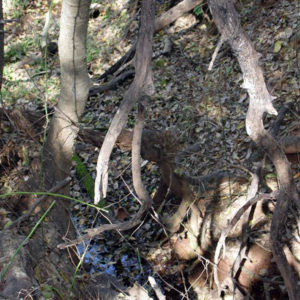
At the site of the springs marked very clearly on the 1871 survey, we found not one spring but two and at least one seep. As described in the old literature, we noted at least three towering and ancient elm trees that no doubt gave the area its name.
The ground nearing the springs falls away toward the river and the immediate area of the springs was split by a high rise that divided two springs, both happily appearing out of dry ground to send cold sweet water toward the river. The photo below is the head of the south spring. It is located less than 600 feet from the Murray Mansion and its location seems to verify early-day accounts of how the Murray family had to haul water around 550 feet to the log cabin they lived in before the mansion was built.
As I would have expected from an enthusiastic Foster girl, Cindy would not allow me to take her picture as she expertly climbed down the bank to the south spring to take a sip of the pristine water. I clung perilously to a steeply inclining bank with my camera, worried I would plunge into the tiny stream and muddy the water. After a long drink, Cindy pronouced the spring cold and sweet, and we agreed that we had found the treasure we were looking for.
We scanned a small area with metal detectors. This complex of springs is just a bit north of where the Elm Springs stage station was located in 1971. We got so many hits that it was hard to know where to dig. It was fun to dig into some of the soil, which was the consistency of chocolate yogurt. When I hit a sandstone ridge just five inches down, the going was not so easy. It seems that not every area is as willing to divulge its secrets as is Maxfield’s Field near where Alex would later be located.
After barely scratching the surface of what Erin Springs has to offer, Cindy and I traced the route of the Fort Cobb Trail back toward Bradley. When she began to tell me the story of a lost Indian graveyard, I was able to finish the tale for her because my own grandfather was there with hers when an early pipeline was put in across the property and revealed the artifacts. My Paw Paw told me that story just as her Granddad told her. Both were long time Alex residents.
Today left me with the belief that our history is still present and just waiting for us to understand and interpret it. It is better shared with friends.